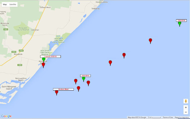
Launch May 1st 2016 - Woodside Beach, Victoria
This launch of Voyager 1 was successful. Follow its path here. The prevailing weather conditions were good for taking the boat well offshore. The offshore winds were due to continue for at least a week, with a series of westerly fronts coming through Bass Strait. This should have been good for fulfilling the plan of getting boat well offshore and down into the southern Tasman Sea. |
| Setting up on the Beach |
 |
| Final Preparations |
 |
| The Launch |
The boat sailed well for the first 8 hours in a SSW direction.
This was ahead of the first of a series of westerly fronts coming in the next week.
The impending westerly wind should have caused the boat to change course from SSW to about WSW.
But it appears to have headed NW instead; and it appeared to travelling upwind at times.
 |
| The First Two Days |
This pattern of movement implies that the boat stopped moving with relation to the wind, and instead started moving with the currents instead.
This implies that the mast was broken and the sail is in the water helping to act as a sea anchor, causing the boat to move with the current, and not be influenced by the wind.It appears that mast was broken when the first front came through on the evening of May 1st 2016.
The weather fronts caused significant damage to properties around Melbourne on the evening of the Launch. News reports of the weather can be seen on The ABC and in The Age.
What was learnt ?
It is an assumption, that the mast is broken, but its hard to imagine another explanation.
The mast was mostly un-stayed, 1m long, 12mm aluminium tubing, with a wall thickness of about 1mm. If it broke, then it was clearly not strong enough for the boat in the conditions experienced.
It will be necessary to consider ways of mitigating this problem in future offshore model boats.
The Flinders Current
The boat is no longer a sailing vessel headed into the southern Tasman Sea as planned. Instead, it is now a drifting buoy, with a Satellite tracking facility.
For the first few days, it travelled fairly distinctly up the Gippsland Coast in a NW direction.
This corresponds to part of the current known as the Flinders Current.
The Flinders Current flows in easterly direction across the south of Australia. It partly flows through Bass Strait, and partly flows up the Gippsland Coast.
This what is moving the boat for the first week.
End of Week 2: May 15, 2016
After 2 weeks at sea, the boat has continued to travel in NW direction up the east Australian coast. At this time it was located over 350km offshore, just south of Sydney.
It movement is under the influence of East Australian Current (EAC). The EAC flows south down the east coast of Australia, close to the mainland down to about the latitude of Sydney. It predominantly flows offshore to the east, at about that point, heading into the Pacific. The edges of the EAC are dominated by eddies that cause significant wandering and circling of the current flow.
May 25 - 25 Days at Sea
After 25 days, the boat is about 1000km from the launch point and about 400km offshore, east of Newcastle. It appears to be on course to drift passed Lord Howe Island and continue into the Pacific. We'll see.
The SPOT GPS Satellite tracking facility is still going well. Without it, We'd have nothing.
No comments:
Post a Comment